Trail Mountain bike Le Bonhomme - Le grand tour du Bonhomme - Photo

Le grand tour du Bonhomme

 tracegps
tracegps

User

© OpenStreetMap contributors
Length
Length
33 km
Max alt
Max alt
1145 m
Uphill gradient
Uphill gradient
991 m
Km-Effort
Km-Effort  
46 km
Min alt
Min alt
661 m
Downhill gradient
Downhill gradient
993 m
Boucle
Boucle
Yes
Creation date :
2014-12-10 00:00:00.0
Updated on :
2014-12-10 00:00:00.0

(1 Reviews)

Mountain bike
Mountain bike
4h30
Difficulty : Difficult

Scan this QR Code to open this trail in the SityTrail application

FREE GPS app for hiking

Logo SityTrail SityTrail

IGN / Geographical institutes

Download SityTrail from the App Store Download SityTrail from Google Play

Logo SityTrail SityTrail World

The world is yours!

Download SityTrail from the App Store Download SityTrail from Google Play Download SityTrail on Huawei AppGallery

About

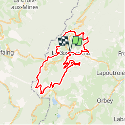
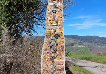
Trail Mountain bike of 33 km to be discovered at Grand Est, Haut-Rhin, Le Bonhomme. This trail is proposed by tracegps.

Description

Circuit de 35 km autour du village du Bonhomme. 1035m de dénivelé cumulé. Circuit difficile avec de nombreux éléments intéressants à voir (étang du Devin, ruines du Gutenbourg, Station du Lac Blanc, etc.)

Elevation profile

Photos

Positioning

Country:
France
Region :
Grand Est
Department/Province :
Haut-Rhin
Municipality :
Le Bonhomme
Location:
Unknown
Start:(UTM)
359749 ; 5337220 (32U) N.

Comments

Please log in to post a review or rate the element


Trails nearby

Trail Walking Le Bonhomme - Tête des faux . - Photo
Walking
heurtinpatrick

Walking

Medium
(1)
Le Bonhomme, Grand Est, Haut-Rhin, France
11.9 km | 16.6 km-effort
3h 46min
Yes
Trail Walking Lapoutroie - 2012-06-16 Marche aux Alisiers Orbey - Photo
Walking
GUIDE
holtzv

Walking

Easy
(2)
Lapoutroie, Grand Est, Haut-Rhin, France
11.1 km | 16.6 km-effort
2h 49min
Yes
Trail Mountain bike Orbey - Lac Blanc  - Têtes des Faux - Photo
Mountain bike
tracegps

Mountain bike

Medium
(1)
Orbey, Grand Est, Haut-Rhin, France
15.3 km | 21 km-effort
1h 0min
Yes
Trail Walking Le Bonhomme - Le Bonhomme - Circuit du village - Photo
Walking
GUIDE
Desrumaux

Walking

Easy
(1)
Le Bonhomme, Grand Est, Haut-Rhin, France
3 km | 5.3 km-effort
1h 30min
Yes
Trail Walking Sainte-Marie-aux-Mines - 2021-02-14 Marche Bagenelles Brezouard Fuste de Etoile - Photo
Walking
GUIDE
holtzv

Walking

Very difficult
Sainte-Marie-aux-Mines, Grand Est, Haut-Rhin, France
17.1 km | 27 km-effort
6h 6min
Yes
Trail Walking Lapoutroie - 2020-07-19 Marche Étang du Devin Col Calvaire Tête des Faux - Photo
Walking
GUIDE
holtzv

Walking

Very easy
Lapoutroie, Grand Est, Haut-Rhin, France
14.2 km | 22 km-effort
3h 27min
Yes
Trail Walking Fréland - CVL - Rando 25/03/2024 - Col de Chamont - Photo
Walking
Hub6877

Walking

Medium
Fréland, Grand Est, Haut-Rhin, France
6.6 km | 9.5 km-effort
2h 15min
Yes
Trail Walking Le Bonhomme - Lac blanc col du calvaire - Photo
Walking
FOUCAULT

Walking

Le Bonhomme, Grand Est, Haut-Rhin, France
5 km | 7.2 km-effort
2h 13min
Yes
Trail On foot Sainte-Marie-aux-Mines - Le Haïcot - Le Petit Brézouard - Le Haïcot - Photo
On foot
patrickbeyrath

On foot

Easy
(2)
Sainte-Marie-aux-Mines, Grand Est, Haut-Rhin, France
7.1 km | 10.5 km-effort
2h 23min
Yes


Close
My subscriptions